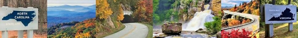
Cherokee To Graveyard Fields On the Parkway
Cherokee To Graveyard Field- A ride on the Blue Ridge Parkway
Everyone has their favorite section of the Blue Ridge Parkway. Cherokee to Graveyard Fields is a favorite for many visitors. A well-known section of the parkway is near Boone, NC. The Linn Cove Viaduct is the most photographed section of the parkway. But there are other sections of the Blue Ridge Parkway in North Carolina that also offer gorgeous views of the southern end of the Blue Ridge Mountains. The highest peak (at 6,053 feet) on the parkway is on this section. The highest peak on the Blue Ridge Parkway is located at Richland Balsam as it passes over Richland Balsam’s southwestern slope.

Mt Mitchell View From Parkway
Mount Mitchell is the highest peak of the Appalachian Mountains. It is not located in the southern section of the Blue Ridge Parkway. Mount Mitchell is north of Asheville in the northern section of the parkway. It is located near Burnsville in Yancy County, NC. Mount Mitchell is visible in the distance from many of the overlooks on the Blue Ridge Parkway. To visit you must exit the parkway. Mount Mitchell and Mitchell State Park are only accessible from the Blue Ridge Parkway by exiting at Milepost 355.4 and taking NC 128 near Black Mountain Gap.
Cherokee To Graveyard Fields
Leaving Cherokee and taking the Blue Ridge Parkway, there are many beautiful overlooks and stops in this lesser travel section of the parkway. In the fall peak colors appear first in many mountain ranges in this part of Western North Carolina. From Cherokee, it takes about an hour to reach Graveyard Fields by the parkway. The speed limit is 45mph. A two-hour round trip there and back to Cherokee is a great way to view some of the highest peaks of the Blue Ridge Mountains.
In Cherokee and just south of the Great Smoky Mountains National Parks, is the junction of the Blue Ridge Parkway and US441. This is the southern end of the BRP with the marker final marker being Milepost 469.1. As you travel along the parkway the mile markers will be decreasing.
Cherokee To Graveyard Fields Overlooks To Enjoy
The first overlook is the Oconaluftee View Overlook at MP 468.4. Looking down from the overlook is a nice view of the Oconaluftee River. The overlook view is on Raven Fork in the Great Smoky Mountains National Park. Cherokee is just minutes away from the southern entrance to the BRP.
Big Witch Overlook at MP 461.9 has an elevation of 4160 feet. The name comes from the last great Cherokee medicine man Big Witch. The view is a prelude to the majestic peaks and valleys you will see along the parkway in this part of the Blue Ridge Mountains.
Watterrock Knob Overlook and Parking is at MP 451.2 with an elevation of 5,820 feet. Waterrock Knob is the location of the highest parkway’s visitor center. The overlook has beautiful long-range views of Appalachian mountain chains. Sunsets and sunrises can be viewed at Waterrock Knob. At the visitors center, you can take a steep trail from the center to the top of Waterrock Knob. The trail is 1.2 miles round-trip. The summit is at 6,273 feet and is the highest point on the parkway. Waterrock Knob is located in the Plott Balsams mountain chain between the Great Smoky Mountains and the Great Balsam Mountains.

Woolyback Overlook
Woolyback Overlook is at Milepost 452.3 with an elevation of 5425feet. From this overlook, you can see the mountainside covered in rhododendron and mountain laurel. The shrubs cover the ridge creating a wooly look. At The Orchards Overlook at MP 444.6 is a view of an old apple orchard that covers the valley of Richland Creek. The overlook has an elevation of 3810feet. It is located in Jackson County, NC near Waynesville.
Balsam Gap Overlook is located at MP 442.2 on the parkway. The overlook is at an elevation of 3630 feet. The view is not a long-range view of mountains and valleys, but of the forest. Balsam and other trees are located in this area of the mountains. Balsam Gap is a mountain pass between the Plott Balsam Range and the Great Balsam Mountains. The Gap is the county line divider for Haywood and Jackson counties. The gap is named for the Great Balsam Mountains in which it lies. Just off the parkway at MP 443.1, take US 23-74 to nearby Balsam, NC.
View Waynesville Overlook is at Milepost 440.9 with an elevation of 4110 feet. At this overlook, you can see the nearby town of Waynesville, NC. The town is situated below in a valley of the Plott Balsam range. It’s a nice scenic view of Waynesville in the distance surrounded by mountains.

Cowee Mountain Overlook
Cowee Mountains Overlook at Milepost 430.7 with an elevation of 5950 feet. This is a popular overlook due to the beautiful view from the parking lot. Just steps out of your vehicle you can take a photo. Mountain range after mountain range, the view is spectacular. If you happen to be at this overlook at sunset you will be gifted with a gorgeous view of the settling sun behind the Nantahala National Forest.

Richland Balsam Overlook
Richland Balsam Overlook is at MP 431.4 with an elevation of 6053 feet. This is the highest point of the Parkway. The overlook gives views of the southern Appalachian Mountains. From the overlook, you can see the Cowees, Nantahalas, and Plott balsams. The highest point you can drive to on the parkway is located at Richland Balsam, elevation 6,047 feet. There are two overlooks for Richland Balsam, near Milepost 431. Haywood-Jackson Overlook. is one. This is where you park for the 1.5-mile loop hike to the top of Richland Balsam. The second is at MP 431.4. There is a large sign ” 6053 feet Highest Elevation Blue Ridge Ridge Parkway Motor Road”.
View Devil’s Courthouse at this BRP overlook at Milepost 422.4. The elevation here is 5462 feet. See the rough and rocky summit of Devil’s Courthouse in the distance. The name comes from the rough and rocky summit that has a devilish appearance. The view from the overlook is nice but the view from the summit is way better. Devil’s Courthouse is one of the most prominent and recognizable mountains along the parkway. For hikers, there is a trail from the parking area to the summit. The summit has a panoramic view of the Pisgah National Forest. Devil’s Courthouse summits at an elevation of 5,720 feet. Due to its elevation, it is one of the first locations on the parkway for fall foliage to appear and peak.
Graveyard Fields Overlook is at MP 418.8 with an elevation of elevation 5120 feet. This area is one of the most popular hiking areas along the parkway. Even in the summer, this area can be quite cool. In the fall this area is one of the first locations along the parkway for fall foliage to appear. In the winter this section of the Parkway is often closed for dangerous road conditions due to ice and snow.

Graveyard Fields View
Graveyard Fields valley can be filled with wildflowers, blueberries, and colorful fall shrubs. The valley is surrounded by tall mountain peaks of the surrounding mountain chains. The name came from how years ago the tree stumps looked like gravestones in a graveyard yard. But years ago storms and a brushfire changed the appearance. There are three waterfalls in the Graveyard Fields that are easily accessible from the Blue Ridge Parkway.
Cherokee Or Asheville
Graveyard Fields is approximately 50 miles from Cherokee. At this point, you can turn around and head back. You can stop at some of the many other overlooks you passed getting to Graveyard Fields. Or you could continue towards Asheville on the parkway. Asheville is 32 miles from Graveyard Fields. The trip to Asheville would be another hour of driving on the Blue Ridge Parkway at 45mph if the parkway isn’t too crowded.
More Views From The Blue Ridge Parkway
-

- Views From The Blue Ridge Parkway
-

- Sunset From Blue Ridge Parkway
-

- BRP Tunnel Oct 2022
-

- View On BRP Oct 2022
-

- NC BRP Oct 2022
-

- NC Mountains From BRP Fall 2022
