Western North Carolina Winter Storm Warning
Western North Carolina Winter Storm Warning Tonight
A Winter Storm Warning as been issued by the National Weather Service for the mountains of North Carolina. Moving in tonight is another cold front and rain that will likely be freezing rain and or sleet to some areas of the NC mountains. This winter weather may bring closures to parts of the Blue Ridge Parkway. Freezing rain and possible sleet is in the forecast for Thursday in the areas of the Northern Mountains, the Western Piedmont Foothills west of Winston Salem)and the Yadkin Valley. There is a possibility of an accumulation of 1/2″ of freezing rain for areas north and west of Hickory, Yadkin Valley, Boone, Mount Airy, and the High Country. freezing rain can accumulate on trees and power lines bringing down limbs and power lines resulting in power outages. Travel can be dangerous in these areas. More closures to the Blue Ridge Parkway are likely for the next few days.

Winter Storm Warning for Western NC
A few sections of the BRP is already closed. The park service made this statement on Tuesday “In the midst of multiple weather related closures at the southern end of the Blue Ridge Parkway, National Park Service officials announce that Tanbark Tunnel at Milepost 374.4 is closed to all uses until further notice due to a piece of the tunnel’s natural rock ceiling coming loose.
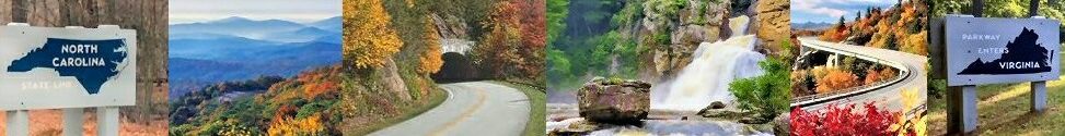
As of now there are four different sections closed: 443.0 to 455.7 Parkway; 344.2 to 355.5 Parkway; 121.2 to 135.9 Parkway and 45.5 to 61.2 Parkway. These areas are closed due to snow and ice from earlier in the week and or fallen trees and tree limbs.
For real-time closures go to Blue Ridge Parkway real-time road open/close status.
A Winter Storm Warning has been issued by the National Weather Service for Western North Carolina…
…ACCUMULATING ICE AND SLEET POSSIBLE TONIGHT INTO THURSDAY
MORNING ACROSS PARTS OF WESTERN NORTH CAROLINA….A deep low pressure system moving east from the plains states
will send abundant moisture into the region atop a wedge of
surface-based cold air tonight. This setup will be favorable for
not only heavy precipitation, but also the development of
freezing rain and sleet – especially over the central and
northern Blue Ridge mountains and the adjacent foothills. Heavy
accumulations of freezing rain and sleet could lead to power
outages and hazardous travel conditions.…WINTER STORM WARNING REMAINS IN EFFECT FROM 7 PM THIS EVENING
TO 1 PM EST THURSDAY ABOVE 2500 FEET……WINTER WEATHER ADVISORY REMAINS IN EFFECT FROM 7 PM THIS
EVENING TO 1 PM EST THURSDAY BELOW 2500 FEET…* WHAT…Heavy mixed precipitation expected above 2500 feet. Mixed
precipitation expected below 2500 feet. Above 2500 feet, total
sleet accumulations of up to one inch and ice accumulations of
up to a quarter of an inch expected. Below 2500 feet, total
sleet accumulations of up to one quarter inch and ice
accumulations of around two tenths of an inch expected.* WHERE…Haywood, Buncombe, Henderson and Transylvania Counties.
* WHEN…From 7 PM this evening to 1 PM EST Thursday.
* ADDITIONAL DETAILS…Plan on slippery road conditions. The
hazardous conditions could impact the morning commute.
Recommended actions
A Winter Storm Warning means significant amounts of snow, sleet
and ice will make travel very hazardous or impossible.
A Winter Weather Advisory means that periods of snow, sleet or
freezing rain will cause travel difficulties. Expect slippery
roads and limited visibilities, and use caution while driving.
Please report snow and ice accumulations by calling the National
Weather Service toll free at…1…800…2 6 7…8 1 0 1. Leave a
message with your observation and the specific location where it
occurred. You can also post your report to National Weather
Service Greenville Spartanburg Facebook or tweet your report
using hashtag nwsgsp.
Stay tuned to NOAA Weather Radio or your favorite source of
weather information for the latest updates. Additional details
can be found at www.weather.gov/gsp.
Please pay attention to the weather report and any winter weather warnings for the area of the Blue Ridge Parkway. More closing are likely if this area does experience freezing rain and sleet resulting in hazardous driving conditions.

Comments
Western North Carolina Winter Storm Warning — No Comments
HTML tags allowed in your comment: <a href="" title=""> <abbr title=""> <acronym title=""> <b> <blockquote cite=""> <cite> <code> <del datetime=""> <em> <i> <q cite=""> <s> <strike> <strong>